 Explore
 Shop
Shop About
About Search
Daily
One regular dose of Earth from above

Parking Lot For Illegal Volkswagens
34.597500°,-117.383056° - Nearmap
Southern California Logistics Airport in Victorville, California is usually used as a graveyard for retired airplanes, but between 2016-2020 served as a parking lot for thousands of diesel-powered Volkswagens. Following an emissions scandal in 2015, Volkswagen leased enough land here to park 21,000 vehicles after giving customers the option to sell back their cars. More than 350,000 customers elected to do so, causing the vehicles to sit in locations like this until they were repaired or approved for export.


Peruvian Coast Farmland
-8.411740°,-78.836610° - Google Timelapse
Agricultural development has greened the coastline of northern Peru, made possible by a decades-long irrigation project. The Chavimochic Special Project, initiated in the 1960s, extends over much of the La Libertad Region to irrigate 556 square miles (1,440 square kilometers) of farmland, nearly half of which was gained from desert. Numerous export crops, like asparagus and artichokes, are grown here.

Zhengzhou
34.764000°,113.684000° - Planet
Zhengzhou is one of the fastest-growing cities in central China, its population climbing from 800,000 to 6.6 million since 1980. Much of its growth has come a manufacturing boom; in fact, it contains the largest smartphone production site in the world and is also known as "iPhone City". Zhengzhou’s metropolitan area covers 1,649 square miles (4,271 square kilometers) along the southern bank of the Yellow River.

Oregon Deforestation
43.845586°,-123.308428° - Google Timelapse
This Overview shows deforestation south of Eugene, Oregon, through clearcutting — a methodical practice of uniformly cutting down trees in a contained area. The process is controversial for its effect on the land’s topsoil, which is also removed with the trees leaving patches of gray deforested areas. Some regrowth can also be seen; Oregon’s land-use laws require loggers to replant five or more trees for every tree that is cut down.

Great Salt Lake
41.166667°,-112.533333° - Google Timelapse
The Great Salt Lake has shrunk by more than two-thirds in 40 years, from a surface area of 3,330 square miles (8,500 square kilometers) in 1980 to a record-low 950 square miles (2,460 square kilometers) in 2021. This trend threatens the residents of nearby Salt Lake City, Utah and millions of other species that depend on the lake such as migratory birds. As more of the lake bed — which contains high levels of arsenic — is exposed, the surrounding atmosphere may become poisoned by toxic dust.

Meta Platforms Campus
37.481292°,-122.153642° - Nearmap
Meta Platform's (formerly Facebook) newest campus in Menlo Park, California was designed by architect Frank Gehry and constructed between 2017 and 2018. The office building, called MPK 21, has nearly 10 acres (4 hectares) of interior space and a 3.6-acre (1.5-hectare) rooftop garden with 200 trees. A water recycling system saves the building around 17 million gallons of water per year, and 1.4 megawatts of solar panels provide a renewable energy source.

Taj Mahal
27.175000°,78.041944° - Airbus Space
The Taj Mahal is an ivory-white marble mausoleum in Agra, India. Commissioned in 1632 by Mughal emperor Shah Jahan as the resting place for his wife. The tomb is the centrepiece of a 17-hectare (42-acre) complex, which includes a mosque, a guest house, and is set in formal gardens bounded on three sides by a fortified wall.

Optus Stadium
-31.951111°,115.889028° - Nearmap
Optus Stadium is a multi-purpose stadium in Perth, Western Australia, constructed between 2014 and 2018. Built on the site of a former golf course, the 60,000-seat stadium can accommodate various sporting and entertainment events including Australian rules football, cricket, rugby and soccer. It is the third-largest stadium in Australia.

Sittaung River
17.081290°,96.955754° - Google Timelapse
The Sittaung River shifts course over time as it empties into the Gulf of Martaban in southern Myanmar. This shifting is partially caused by a tidal bore at the mouth of the river — a strong current that pushes back against the river, temporarily reversing its flow. The Sittaung discharges an average of 12 cubic miles (50 cubic kilometers of water per year.

Erbil
36.191188°,44.009189° - Planet
Erbil is the capital and most populated city in Iraq’s Kurdistan Region, with around 1.5 million inhabitants. At the city’s center is the Citadel of Erbil, a 102,000-square-meter (1.1 million-square-foot) mound believed to be the oldest continuously inhabited town in the world. Surrounding the Citadel are a series of concentric ring roads.

Santa Cruz Resettlement
-16.622791°,-62.910703° - Planet
Large tracts of rainforest in Santa Cruz, Bolivia have undergone major deforestation since the 1980’s to make way for resettlement and agricultural projects. The pinwheel-patterned fields seen here follow the San Javier resettlement scheme, with each pinwheel containing a central community that includes a church, bar/café, school, and soccer field. The light-colored areas of the formations are primarily fields of soybeans, and the dark lines running through the fields are “windbreaks” that prevent the erosion of the area’s unusually fine soil.

New Suez Canal
30.537447°,32.334090° - Maxar
The Suez Canal was expanded between 2014 and 2015, when a second channel was dredged near the city of Ismailia, Egypt. This channel, dubbed the “New Suez Canal,” spans 22 miles (35 kilometers) between the Great Bitter Lakes and El Ballah bypasses, allowing ships to transit the canal in both directions simultaneously. It nearly doubled the capacity of the Suez Canal, from 49 to 97 ships per day.
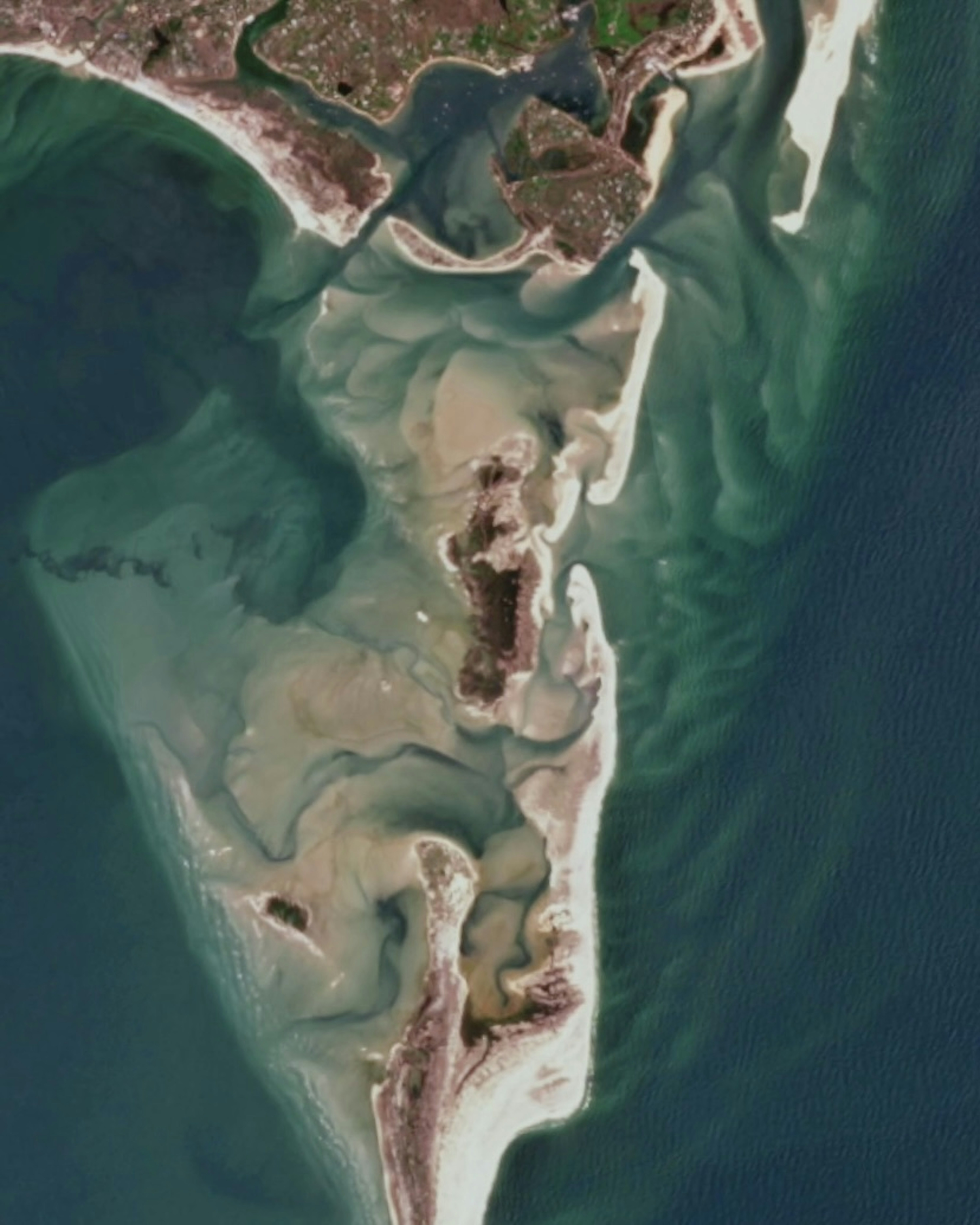
Monomoy Island Wildlife Refuge
41.627828°,-69.966681° - Planet
Sand stretches off the elbow of Cape Cod, Massachusetts, shifting over the years with the currents of the Atlantic Ocean. This particular area lies within the Monomoy Island National Wildlife Refuge, a migratory bird sanctuary with varied habitats including salt and freshwater marshes, sand dunes, and ponds.
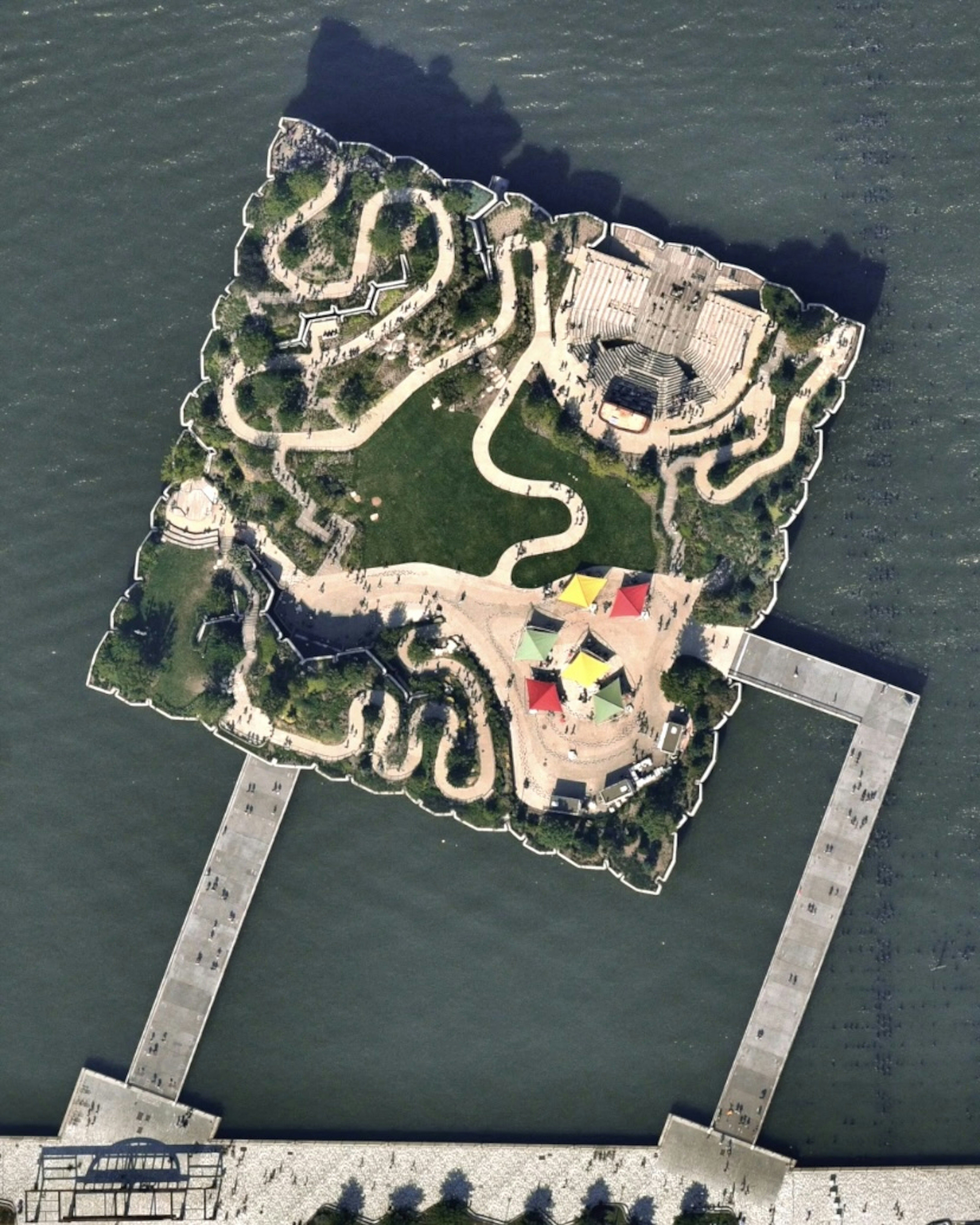
Little Island
40.741966°,-74.010184° - Nearmap
Little Island is a public park in Manhattan, New York City that was constructed between 2018 and 2021. The 2.4-acre (9,712-square-meter) space is perched above the Hudson River on 132 concrete “tulip” pillars. It contains more than 350 species of plants, a 687-seat amphitheater, and ample lawn space for visitors.
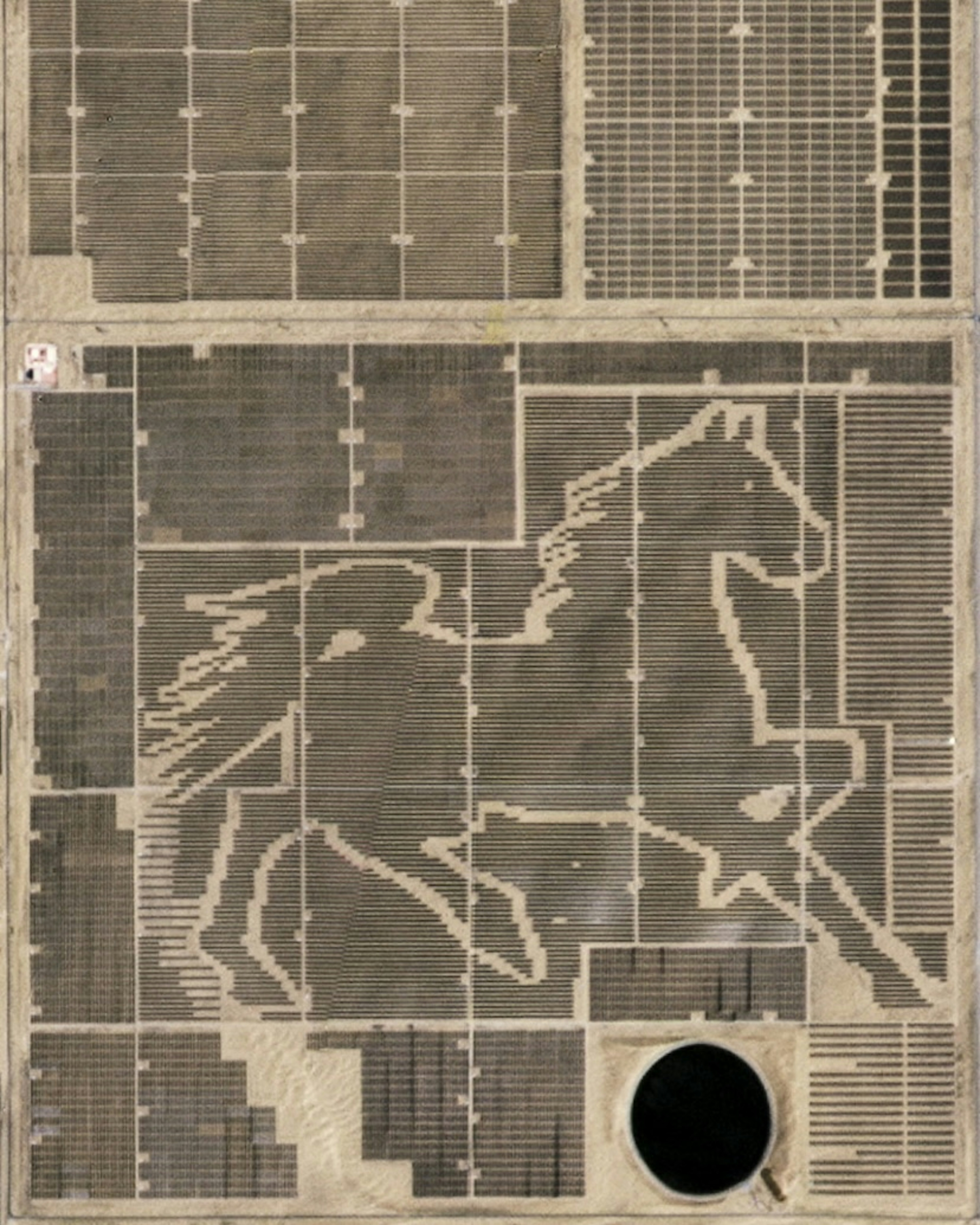
Solar Panel Horse
40.295360°,109.670942° - Planet
The world’s largest solar panel image - a horse - was constructed in the Kubuqi Desert of Inner Mongolia, China starting in 2017. This massive pattern was built with 196,320 solar panels and covers nearly 1.4 square kilometers (0.54 square miles). It is part of a larger photovoltaic generation base with an annual output of 4 billion kilowatt hours.
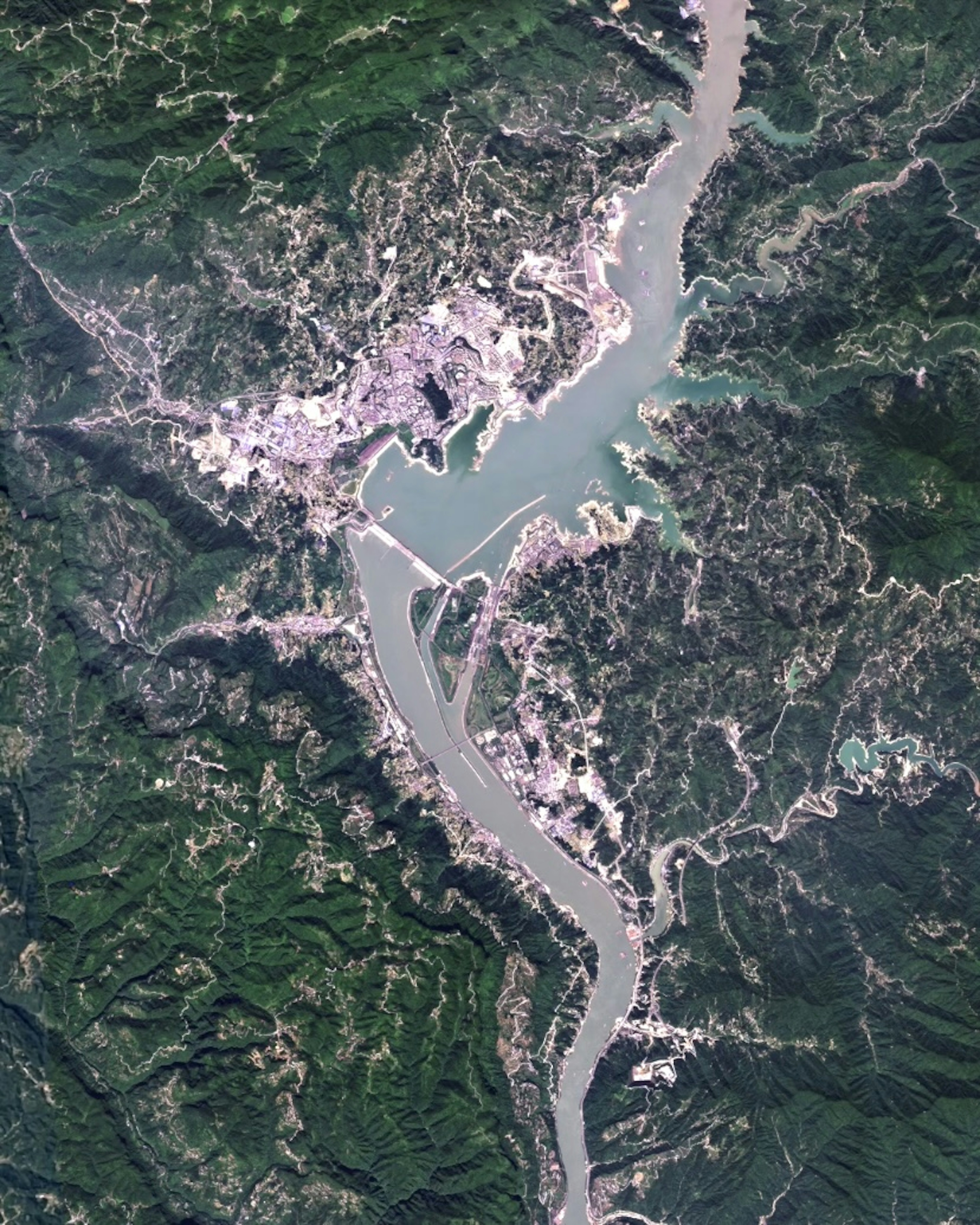
Three Gorges Dam
30.823056°,111.003333° - Planet
Three Gorges Dam, which spans the Yangtze River in central China, was constructed between 1994 and 2012 to produce electricity and increase river shipping capacity. Since opening, it has been the world's largest power station in terms of installed capacit with 22,500 megawatts. Its construction also caused a massive relocation upstream — 1.24 million people were forced to move and 13 cities, 140 towns, and 1350 villages were at least partially flooded.
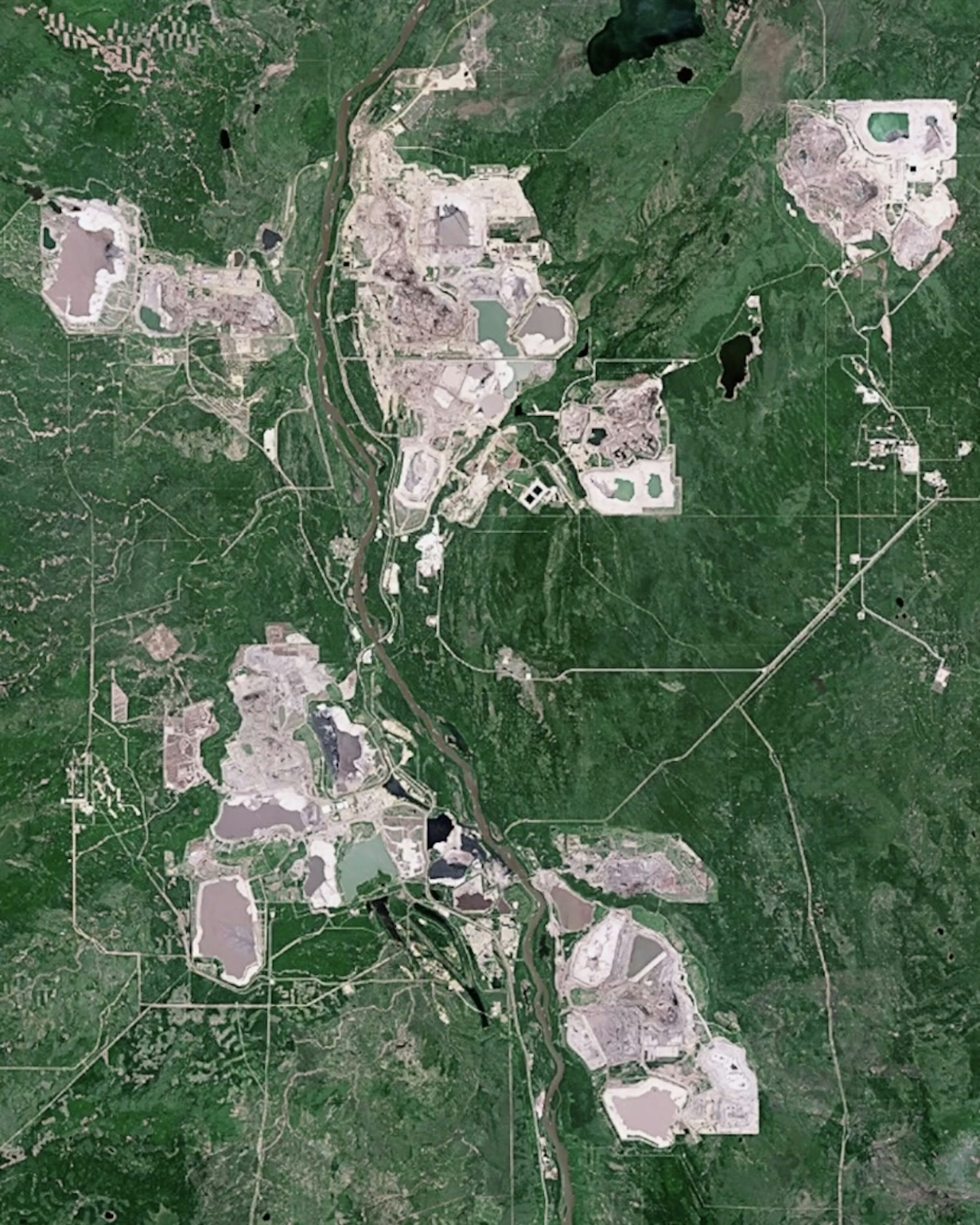
Athabasca Oil
57.020000°,-111.650000° - Planet
The Athabasca Oil Sands in Alberta, Canada now cover roughly 100 square miles (258 square kilometers). The facility has expanded as its production of oil increased since the 1990s - an average of 3.1 million barrels were extracted each day in 2018, which is four times as much as in 2005. Athabasca contains Earth’s largest known deposit of bitumen, a semi-solid form of crude oil that occurs as a mixture of sand, clay, and water. The additional energy required to mine and then remove the sand from the bitumen releases more emissions than in any other form of oil production. The entire Athabasca area contains enough oil to produce 2.5 million barrels per day for the next 185 years.
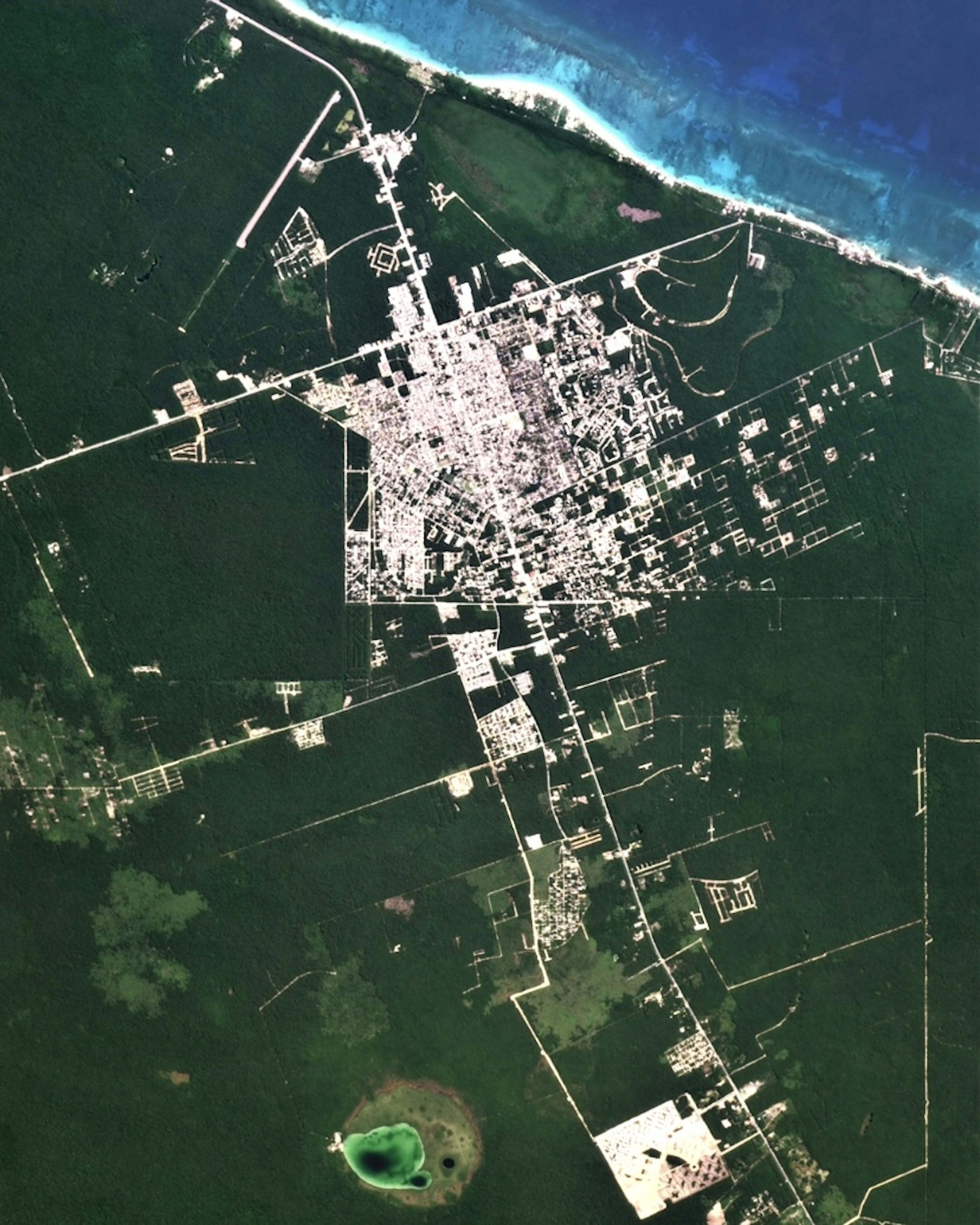
Tulum
20.211944°,-87.465833° - Planet
Until the early 1990s, Tulum was a quiet village on Mexico’s Caribbean coast. Known for its beaches and well-preserved Mayan ruins, the community has swelled in recent years to accommodate a rapid increase in tourism. It’s population grew from 3,000 in 1995 to over 46,000 in 2020, and its infrastructure now includes hotels, restaurants and bars, boutiques, and gyms.
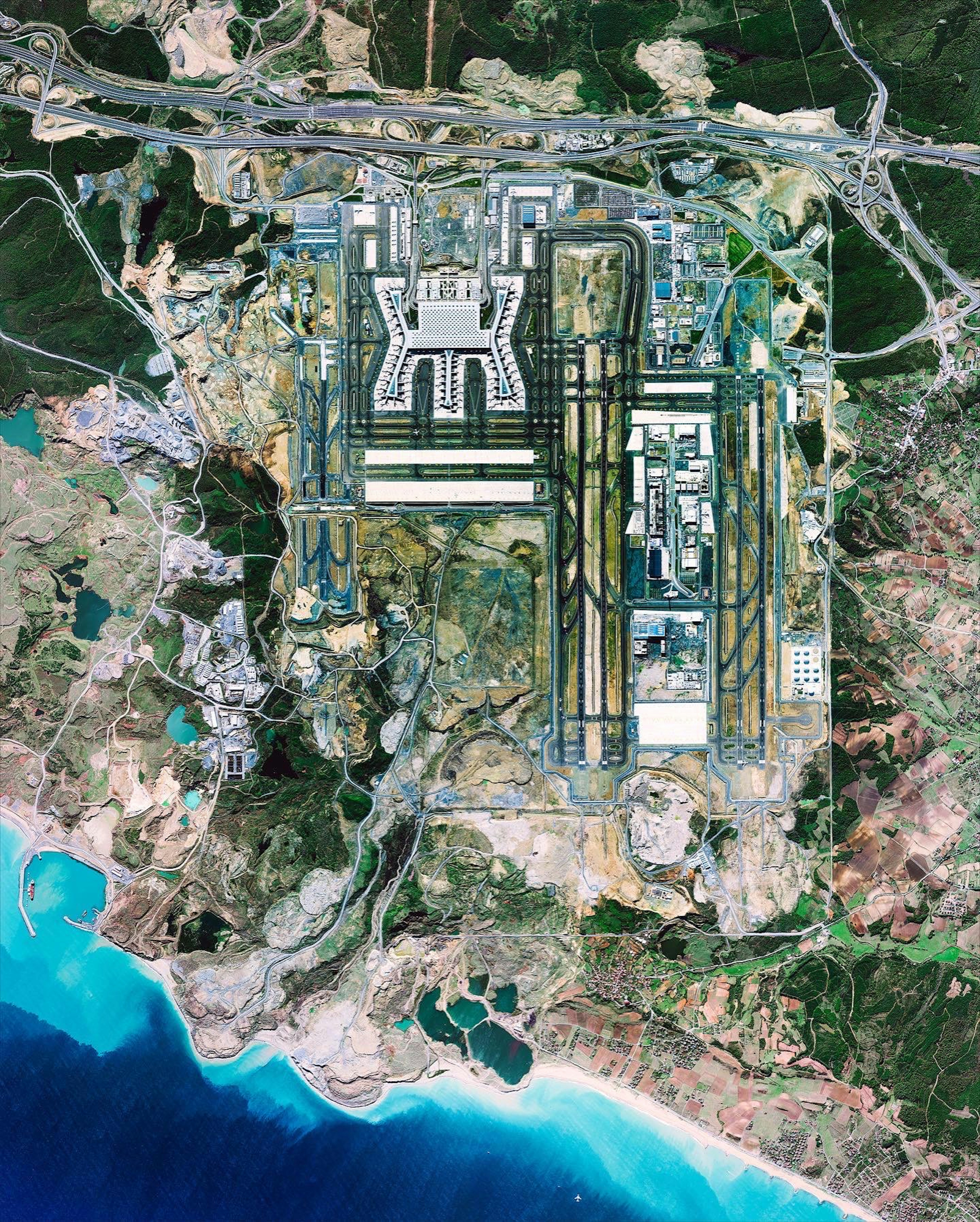
Istanbul Airport
41.262222°,28.727778° - Maxar
Construction of Istanbul Airport began in 2014 and took four years to complete. Most of its 19,000-acre (7,600-hectare) footprint was previously state-owned forest and some 658,000 trees were cleared to make way for its construction. The facility has an annual passenger capacity of 90 million people.
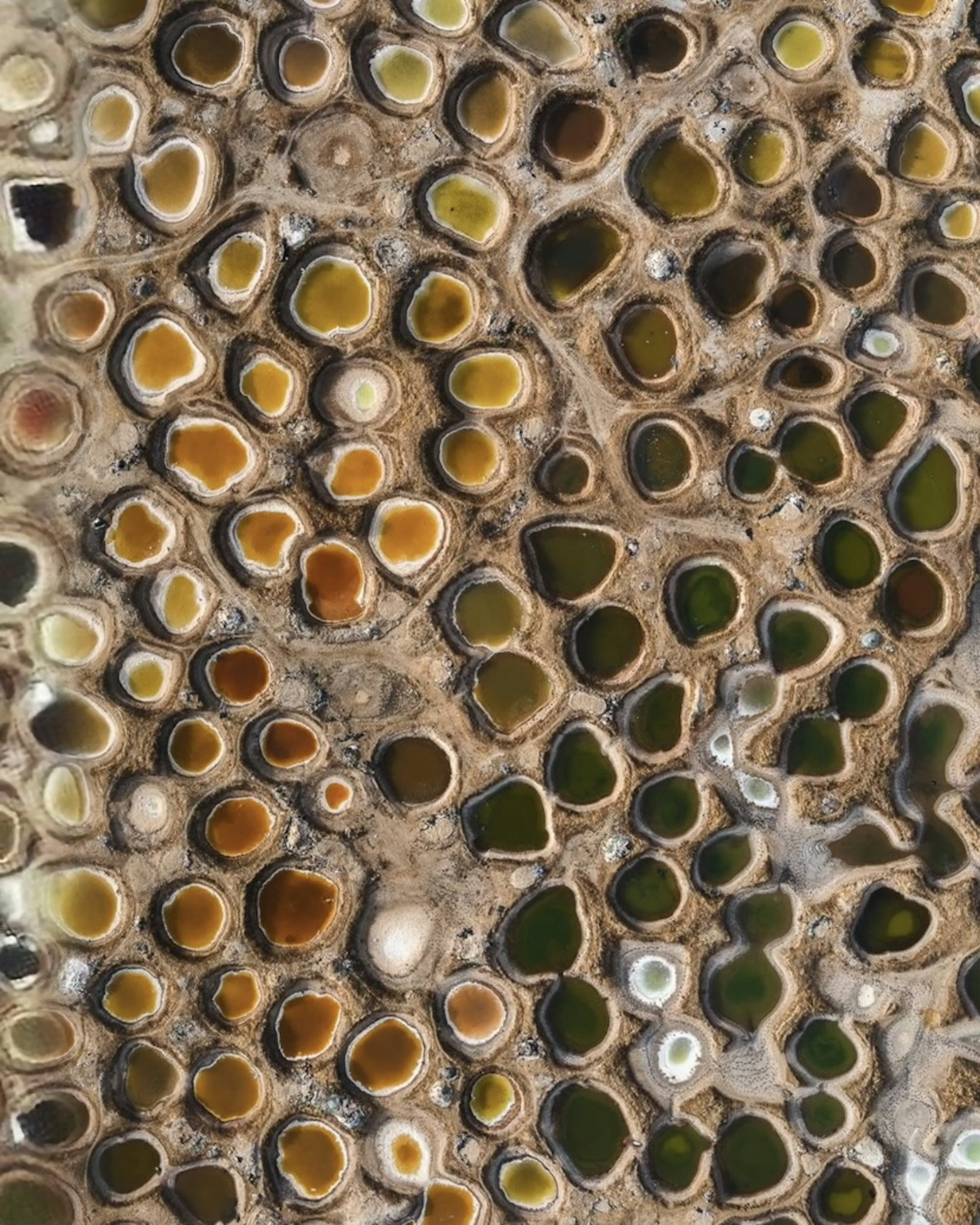
Senegal Salt Ponds
14.055530°,-16.764616° - Tom Hegen
Man-made salt ponds dot the Saloum River Delta in Senegal, West Africa. Solar evaporation turns the water into a salty brine and, due to variable algal concentrations, creates vivid colors ranging from pale green to bright orange. In summer months, the brines turn dense enough to crystallize and salt crystals sink to the bottom, where they can be scooped out.