 Explore
 Shop
Shop About
About Search
Daily
One regular dose of Earth from above
Florence
43.783333°,11.250000° - Maxar
Florence, the capital of Italy’s Tuscany Region, is seen here flanking the Arno River. Noted for its culture, Renaissance art and architecture, monuments, and museums, the city attracts millions of tourists every year. Among Florence’s many red terra-cotta roofs, we can see one of its most iconic sights — the Santa Maria del Fiore, or Florence Cathedral, which is home to the largest dome built of brick and mortar in the world.


Chicama, Peru
-8.005722°,-79.188250° - Maxar
Waves roll in to Chicama, Peru. This area is well known for having one of the longest surfs in the world, especially at “The Point,” a spot where you can allegedly surf a single wave for slightly more than a mile (2 km) if conditions are right.
Hulhumalé
4.180755°,73.534472° - Maxar
Hulhumalé is an artificial island in the Maldives, gradually formed by land reclamation since 1997. Now 2 square miles (4 sq. km) with a population near 100,000, the island was built to ease congestion on nearby Malé, which lies opposite Velana International Airport. With a population of 252,768 in an area of 3.2 square miles (8.3 sq. km), Malé is one of the most densely populated cities in the world.
Seattle
47.609722°,-122.333056° - Nearmap
Seattle is the most populous city in the state of Washington, with a population of roughly 750,000. Situated on an isthmus between the Puget Sound and Lake Washington, the city is a major gateway for trade with Asia. This Overview shows several neighborhoods north of the city center, including Eastlake, Portage Bay, Montlake and others.
Libya Irrigation
26.972480°,22.215840° - NASA / Google Timelapse
In Libya, where 90% of land is desert and just 2% gets enough rainfall for cultivation, irrigation is required to grow food. This Overview shows a series of center-pivot irrigation fields near the Kufra Oasis, one of Libya’s largest agricultural projects. Irrigation throughout Libya relies on the “Great Man-made River” — a 2,820-kilometer (1,750-mile) network of pipes supplying fresh water obtained from underground fossil aquifers.

Sundarbans
21.950000°,89.183333° - NASA
The Sundarbans is a region that covers 3,900 square miles (10,000 square km) of southern Bangladesh and a small section of Eastern India. This region is densely covered by mangrove forests and contains the largest natural reserve for the Bengal tiger. Over the past two centuries, approximately 2,600 square miles (6,700 square km) of the Sundarbans’ land has been developed.

Guayas River Estuary
-2.208180°,-79.942960° - Maxar
Guayaquil, Ecuador, sits on the upper stretches of the Guayas River estuary, adjacent to a 235-square-mile (608-sq.-km) network of tributaries and mangrove forests. Since the 1970s, commercial shrimp farms have become commonplace in the estuary, leading to mangrove deforestation. This presents a conflict for Guayaquil, which benefits from shrimp exporting but is the planet’s fourth-most vulnerable city to future flooding due to climate change.
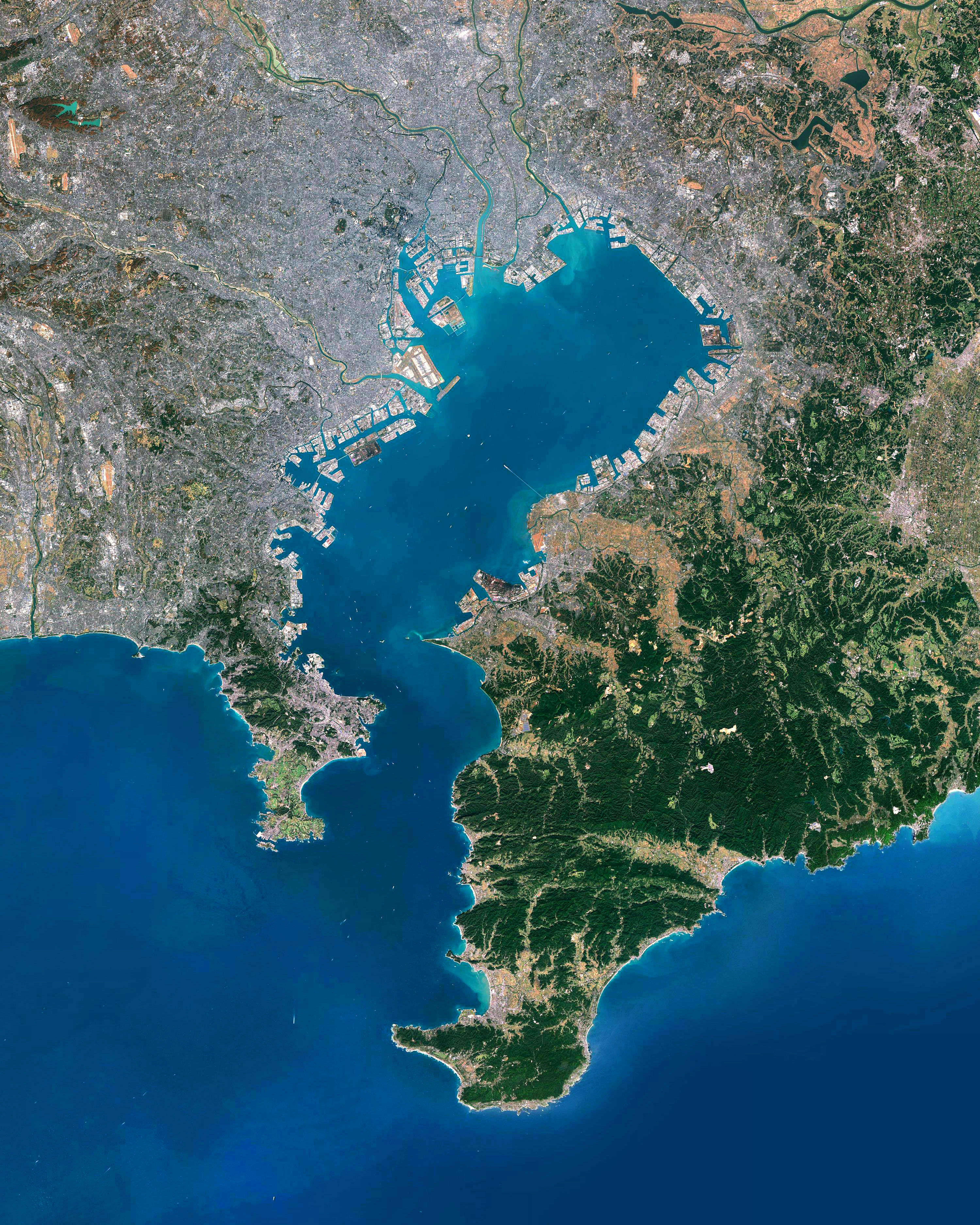
Greater Tokyo
35.689722°,139.692222° - Airbus Space
Greater Tokyo, Japan, is one of the most populated and industrialized regions in the world. Encompassing several major cities, including Tokyo, Kawasaki and Yokohama, it is home to more than 38 million people. The so-called “Capital Region” also has the largest metropolitan economy in the world, with a total gross domestic product (GDP) of about $1.8 trillion.

Night of Power
21.422500°,39.826111° - Masjid Al Haram
A record 2.5 million Muslims gathered at the Great Mosque in Mecca, Saudi Arabia, last Friday to mark the Night of Power, one of the holiest nights of Ramadan. At center is the Kaaba, a cuboid stone structure that Muslims believe to be the Bayt Allāh, or “House of God.” Ramadan, the ninth month on the Islamic calendar, concluded on Tuesday with Eid al-Fitr.

Monaco
43.733333°,7.416667° - Maxar
Monaco is a sovereign city-state on the French Riviera on the Mediterranean Sea. With an area of 0.81 square miles (2.1 square kilometers), it is the second smallest country in the world, after Vatican City. This Overview features Port Hercules, the nation’s only deep-water port, as well as the Monte Carlo Casino and the Circuit de Monaco, the street course used for the annual Monaco Grand Prix Formula One race.

Big Sur Road Collapse
36.380383°,-121.901453° - Justin Sullivan/Getty Images
Parts of California’s scenic Highway 1 have been collapsing into the Pacific Ocean in recent days, as bouts of rain lead to landslides. Today, state officials temporarily shut down a stretch of the road near Big Sur and urged local residents to evacuate since more rain is expected through Friday. Around 2,000 people live in the Big Sur area year-round.

Sydney Holdout House
-33.710156°,150.895524° - Nearmap
A home in The Ponds neighborhood of Sydney, Australia, has gradually been surrounded by suburban development, as the family who owns it has declined to sell for decades. Despite offers as high as $50 million, the Zammit Family refuses to sell developers their 5-acre (2-hectare) lot, which could accommodate 40-50 new properties. This Timelapse video shows the neighborhood between 2010 and 2024.

Key Bridge Cleanup
39.216944°,-76.528333° - Nearmap
Clean-up work continues on the collapsed Francis Scott Key Bridge in Baltimore, Maryland, which was struck by a container ship and critically damaged on March 26th. The cargo ship “Dali” remains stationary while crews use cranes to remove large pieces of twisted steel and concrete from the wreckage. One of the largest cranes on the Eastern Seaboard, capable of lifting 1,000 tons, is assisting with the effort.

Roswell Air Center
33.301556°,-104.530556° - Nearmap
We found something unusual in this Overview of the Roswell International Air Center in Roswell, New Mexico. The airport, which served as a U.S. Army airfield during World War II and as Walker Air Force Base during the Cold War, is now a commercial airport serving the southwestern USA. It is known for the 1947 Roswell incident, a series of events surrounding the crash a U.S. Army Air Forces high-altitude balloon that involved theories about UFOs and extraterrestrials.

Ras El-Bar
31.512500°,31.825556° - Maxar
Ras El-Bar is an Egyptian resort city, located on a peninsula along the Mediterranean Sea at the mouth of Damietta Branch of the Nile. It has a gridded street plan and contains numerous “e’sha” — small, square, uniform villas made of cement or brick. The city of Izbat Al Burj, which has a more natural layout, is seen across the Damietta.

Francis Scott Key Bridge Collapse
39.219216°,-76.525551° - WBAL-TV
The Francis Scott Key Bridge in Baltimore, Maryland, collapsed early this morning after it was struck by a large container ship. The 1.6-mile bridge, which crosses the Patapsco River and is part of Interstate 695, broke to pieces and fell into the river below. Several vehicles were plunged into the water; two people have been rescued and crews continue to search for others. An estimated 11.5 million vehicles crossed the bridge annually in recent years.
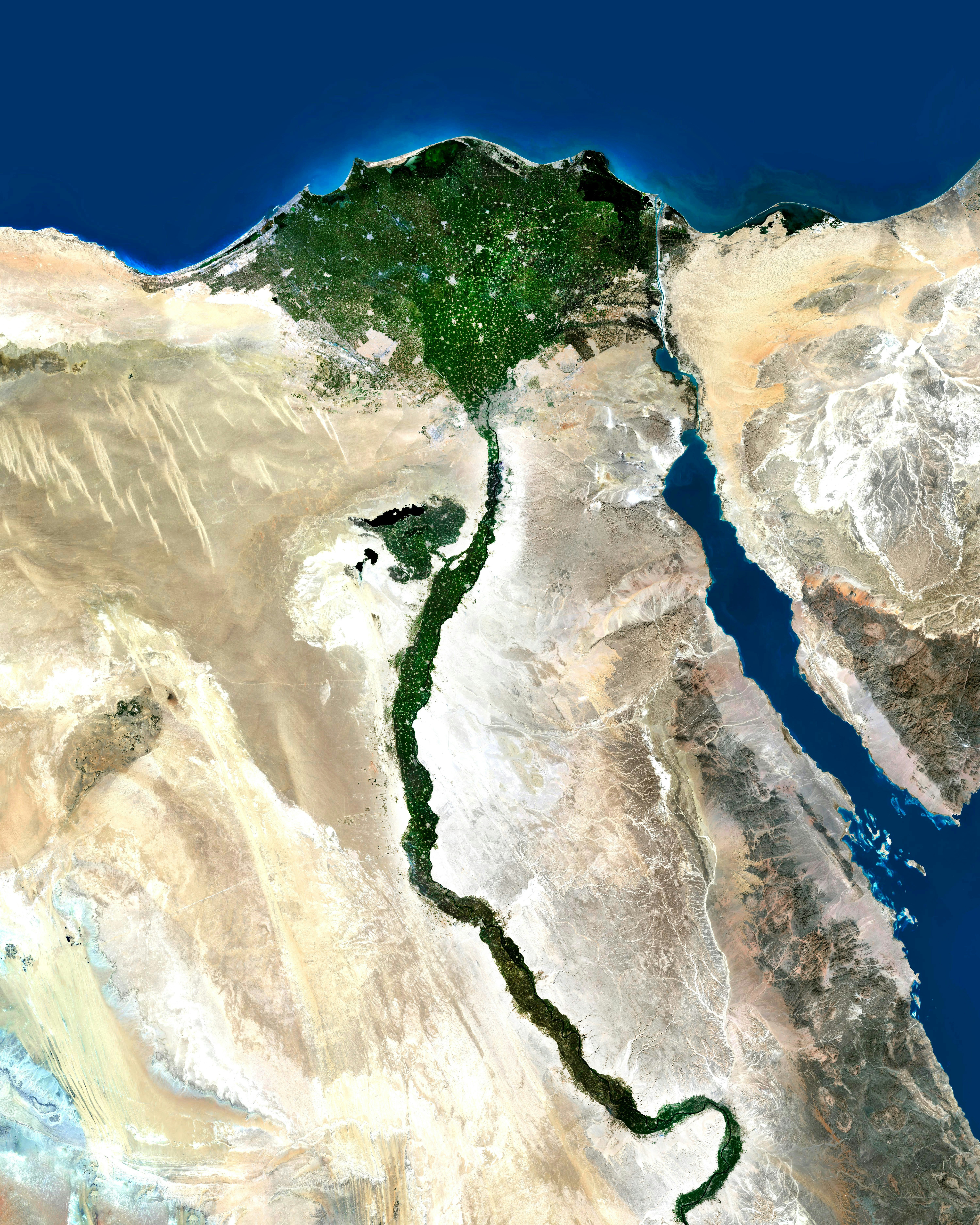
Nile River
29.336389°,31.224667° - Airbus Space
The Nile River is commonly regarded as the longest river in the world, flowing for 4,258 miles (6,853 km) over 11 countries in northeastern Africa. In this Overview, it is shown flowing north through Egypt, forming a large delta before emptying into the Mediterranean Sea. Civilizations since ancient times have depended on the waters of the Nile to flood and fertilize the surrounding desert lands.

Gwangyang Steel Works
34.914935°,127.740139° - Maxar
The Gwangyang Steel Works in Gwangyang, South Korea is the largest facility of its kind in the world. It outputs an average of 18 million tons of steel per year, producing parts for bridges and other infrastructure, cars, refrigerators, and more. The plant even serves as a tourist attraction, receiving hundreds of thousands of visitors from around the world.

Washington Monument
38.889469°,-77.035258° - NASA HQ PHOTO via Flickr
To celebrate President’s Day in the United States, here is the Washington Monument — an obelisk located on the National Mall in Washington, D.C. Standing 554 feet 7 11/32 inches (169.046 m) tall, the structure was built to commemorate George Washington, the first U.S. President. It was completed in 1885; is made out of marble, granite, and bluestone gneiss; and is the world's tallest predominantly stone structure.

Matuku
-19.159465°,179.765080° - Maxar
Happy Valentine’s Day! We’re spreading the love today with this Overview of Matuku, a heart-shaped island in Fiji’s Lau archipelago. The 22-square-mile (57 sq. km) island is surrounded by a lagoon and a barrier reef. It contains several small villages and has a total population of about 550 people.