Explore
 Shop
Shop About
About Search
Overview Index
Makoko
6.495556°, 3.394167° - Lagos, NigeriaMakoko is a floating village in Lagos, Nigeria. Residents, approximately 85,000 in total, use wooden canoes to navigate the narrow canals and move about the neighborhood. In recent years, there has been great dispute over this area as the government has attempted to demolish homes to allow for the construction of more valuable, waterfront real estate.
Maxar Technologies
Malé
4.173715°, 73.509263° - Republic of MaldivesMalé is the capital and most populous city in the Republic of Maldives. With more than 47,000 residents per square kilometer (0.39 square miles), the heavily urbanized city constitutes the fifth most densely-populated island in the world. Malé and the other islands of the Maldives are located one meter (3 feet) above sea level.
Maxar Technologies
Malé, Maldives
4.175278°, 73.508889° - 4.175278°, 73.508889°Malé is the capital and most populous city in the Republic of Maldives, a nation of islands in South Asia. With a population of about 133,000 in an area of 2.24 square miles (5.8 square km), it is the fifth most densely populated island on Earth. Since it has no surrounding countryside, all of Malé’s utilities are located in the city proper and sewage is pumped unprocessed into the sea.
Maxar Technologies
Manhattan
40.758977°, -74.108972° - New York, New York, USAManhattan is the most densely populated borough in New York City and is home to roughly 1.6 million people. With an area of nearly 23 square miles, there are approximately 72,000 people for every square mile.
Maxar Technologies
Manheim Auto Auction Lot
40.140361°, -76.396770° - Manheim, PennsylvaniaVehicles await auction on a large lot in Manheim, Pennsylvania. Founded in 1945, this facility is the world’s largest wholesale auto auction, handling around 8 million vehicles per year at more than 100 locations worldwide. The lot seen in this Overview is approximately 500 acres (200 hectares) in size.
Nearmap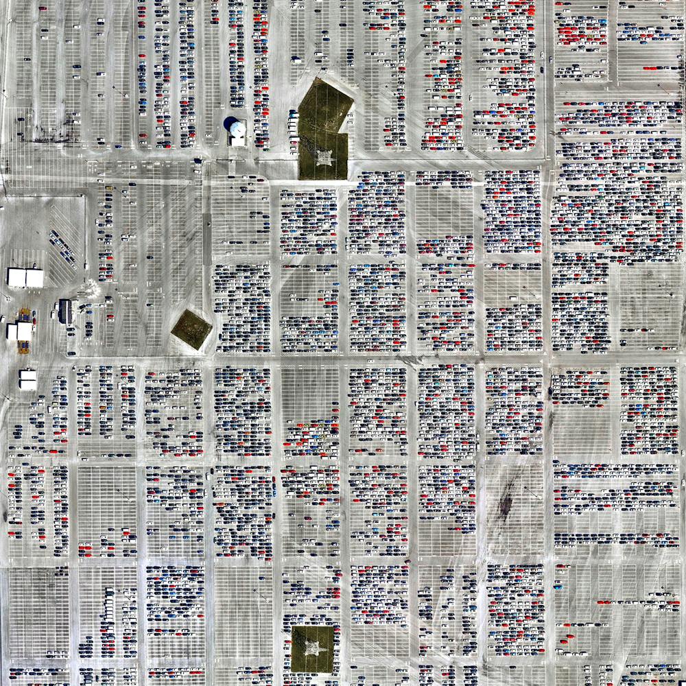
Manzhouli
49.491810°, 117.280617° - Manzhouli, Inner Mongolia, ChinaManzhouli is a sub-prefectural city in the Inner Mongolia Autonomous Region of China. Located on the border with Russia, it is a major land port of entry and has experienced a boom in recent years as a center of Sino-Russian trade. Since China restricted commercial logging two decades ago, hundreds of factories have opened in Manzhouli to take advantage of lumber from Russia — demand for which is depleting many of Russia's forests.
Maxar Technologies
Marabe Al Dhafra
23.611166°, 53.706629° - Abu Dhabi, United Arab EmiratesThe villas of Marabe Al Dhafra in Abu Dhabi, United Arab Emirates are home to approximately 2,000 people. The yearly average temperature in Abu Dhabi is slightly greater than 94 degrees Fahrenheit (34.5 degrees Celsius).
Maxar Technologies
Marblehead Boats
42.495346°, -70.848786° - Marblehead, Massachusetts, USAHundreds of boats take harbor in a bay next to Marblehead, Massachusetts, a coastal town roughly 16 miles (25km) north of Boston. With a population of about 20,000, Marblehead has roots in commercial fishing, whaling, and yachting. In fact, it is often referred to as the birthplace of the United States Navy, as many of its resident sailors played a pivotal role in the American Revolution.
Nearmap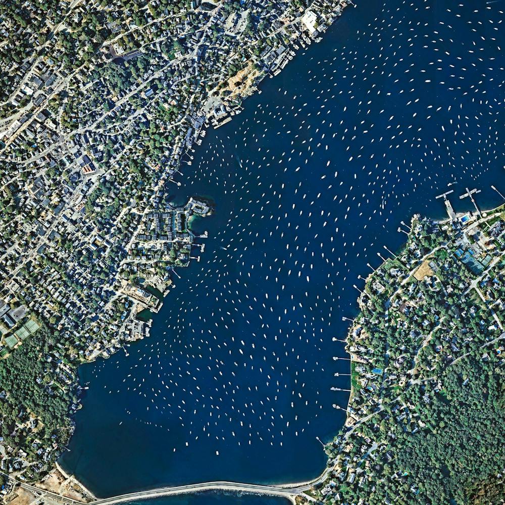
March For Our Lives
38.893596°, -77.014570° - Washington, D.C., USAAn estimated crowd of 200,000 people attended the March For Our Lives in Washington, D.C., on Saturday. A section of Pennsylvania Avenue, stretching from the U.S. Capitol Building up towards The White House, is seen covered with participants here. Led by students from Marjory Stoneman Douglas High School, the march sought to raise awareness of gun violence and called for increased gun control legislation. In addition to the event in Washington, hundreds of others took place throughout the United States and around the world.
Maxar Technologies
Marrakesh
31.633083°, -7.986167° - Marrkesh, MoroccoThe medina quarter in Marrakesh, Morocco, is characterized by its winding, maze-like streets. Since the intricately connected honeycomb of alleyways narrows to less than a meter (~ 3 ft) wide in certain spots, the area is generally free from car traffic.
Maxar Technologies
Maurtitius Ocean Currents
-20.473306°, 57.309250° - MauritiusJust off the southwestern corner of Mauritius (shown at the center of this Overview) is what appears to be an underwater waterfall. In reality, it is just the flow of underwater currents and sand patterns on the ocean floor that form this spectacular optical illusion from the aerial perspective. Mauritius is an island nation in the Indian Ocean, roughly 1,200 miles (2,000 km) off the southeastern coast of Africa.
Maxar Technologies
McMurdo Station
-77.840119°, 166.644358° - Ross Island, AntarcticaMcMurdo Station is a United States research center on the southern tip of Ross Island in Antarctica. It is one of three U.S. Antarctic science facilities and the largest community on the continent, capable of supporting 1,258 residents. It boasts a harbor, three airfields, a heliport, more than 100 buildings, and Antarctica’s only two ATMs.
Maxar Technologies
Medina quarter
31.633081°, -7.986173° - Marrakesh, MoroccoThe medina quarter in Marrakesh, Morocco is characterized by its winding, maze-like streets. Because the intricately connected honeycomb of alleyways narrows to less than a meter wide (~ 3 feet) at certain spots, the area is generally free from car traffic.
Maxar Technologies
Melbourne
-37.813611°, 144.963056° - Melbourne, AustraliaMelbourne is the second most populous city in Australia with upwards of 5 million residents — about one-fifth of nation's total population. Its metropolitan area is made up of 31 municipalities and covers a sprawling 3,858 square miles (9,992 sq. km) surrounding much of Port Phillip Bay. Melbourne is considered one of the most livable cities in the world, receiving high marks for entertainment, tourism, education, health care, research and development on the Economist Intelligence Unit's Liveability Index.
Maxar Technologies
Melbourne Skeleton Mural
-37.711934°, 144.992803° - Melbourne, AustraliaA mural of a pink skeleton covers the grounds at Reservoir Skatepark in northern Melbourne, Australia. This piece spans roughly 20,000 square feet (1,858 sq. m) and is one of many large murals in the area created by local artist Kitt Bennett. For a sense of scale, 20,000 square feet is nearly half the size of an American football field.
Nearmap
Melrose Park
-32.016664°, 69.955090° - Fort Lauderdale, Florida, USAMelrose Park is a residential community in Fort Lauderdale, Florida, USA. The neighborhood is planned with streets in eight concentric octagons and contains 1,975 households.
Maxar Technologies
Memorial City Interchange
29.784528°, -95.563194° - Memorial City, Texas, USAA stack interchange forms at the intersection of Beltway 8 and Interstate 10 in Memorial City, Texas. Officially known as the “Memorial Management District,” Memorial City is a commercial district of Houston. Stack interchanges eliminate the problems of vehicle weaving, but have a large footprint and are widely considered to be an eyesore by those who live near them.
Nearmap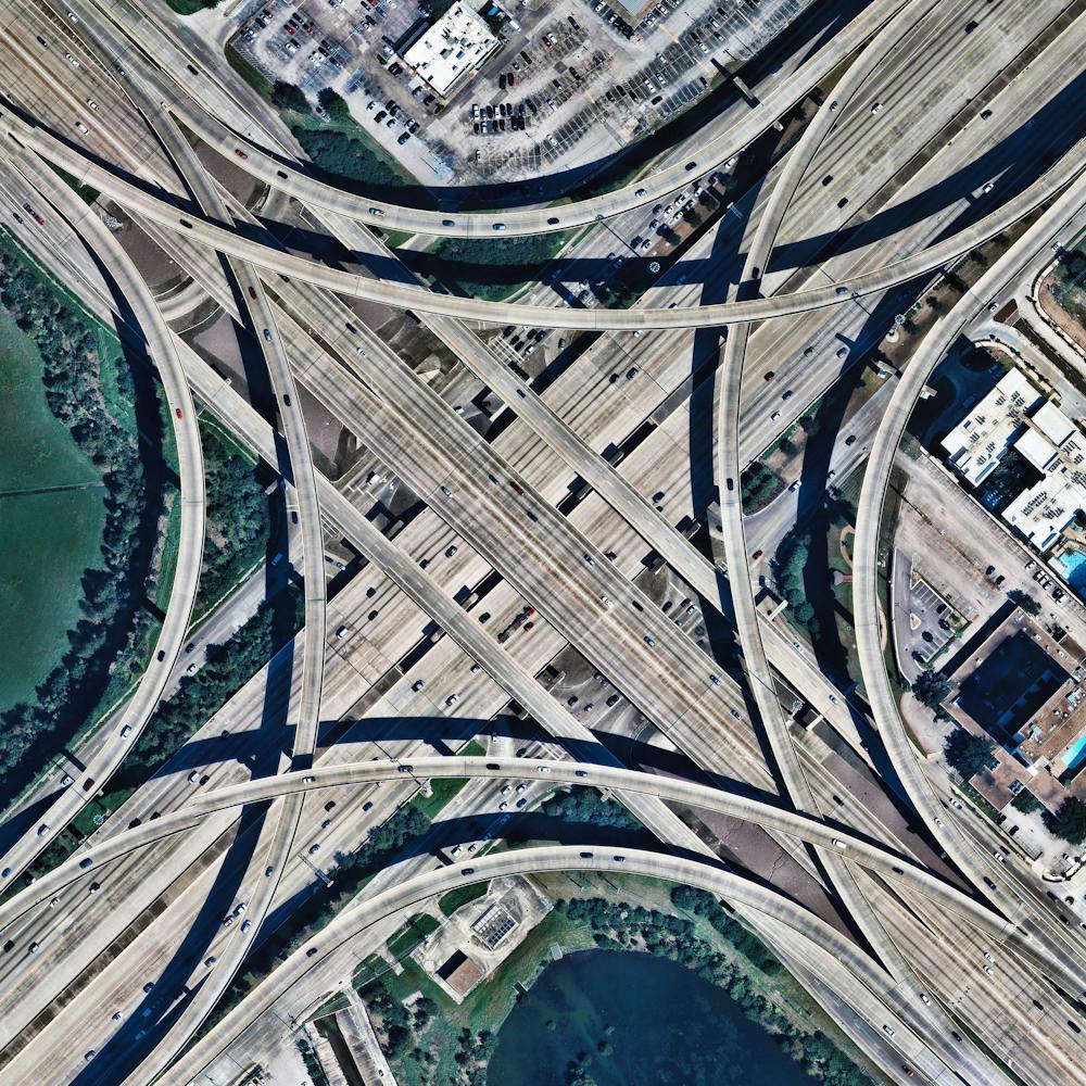
Mendoza, Argentina Road Grid
-37.035056°, -69.451639° - Mendoza Province, ArgentinaRoads create a grid-like pattern on the landscape in a remote section of Argentina’s Mendoza Province. This area has an arid climate and receives anywhere from 4 to 20 inches (100-500 mm) of precipitation per year. These conditions cause much of the soil to be dry and reddish, as shown in this Overview.
Maxar Technologies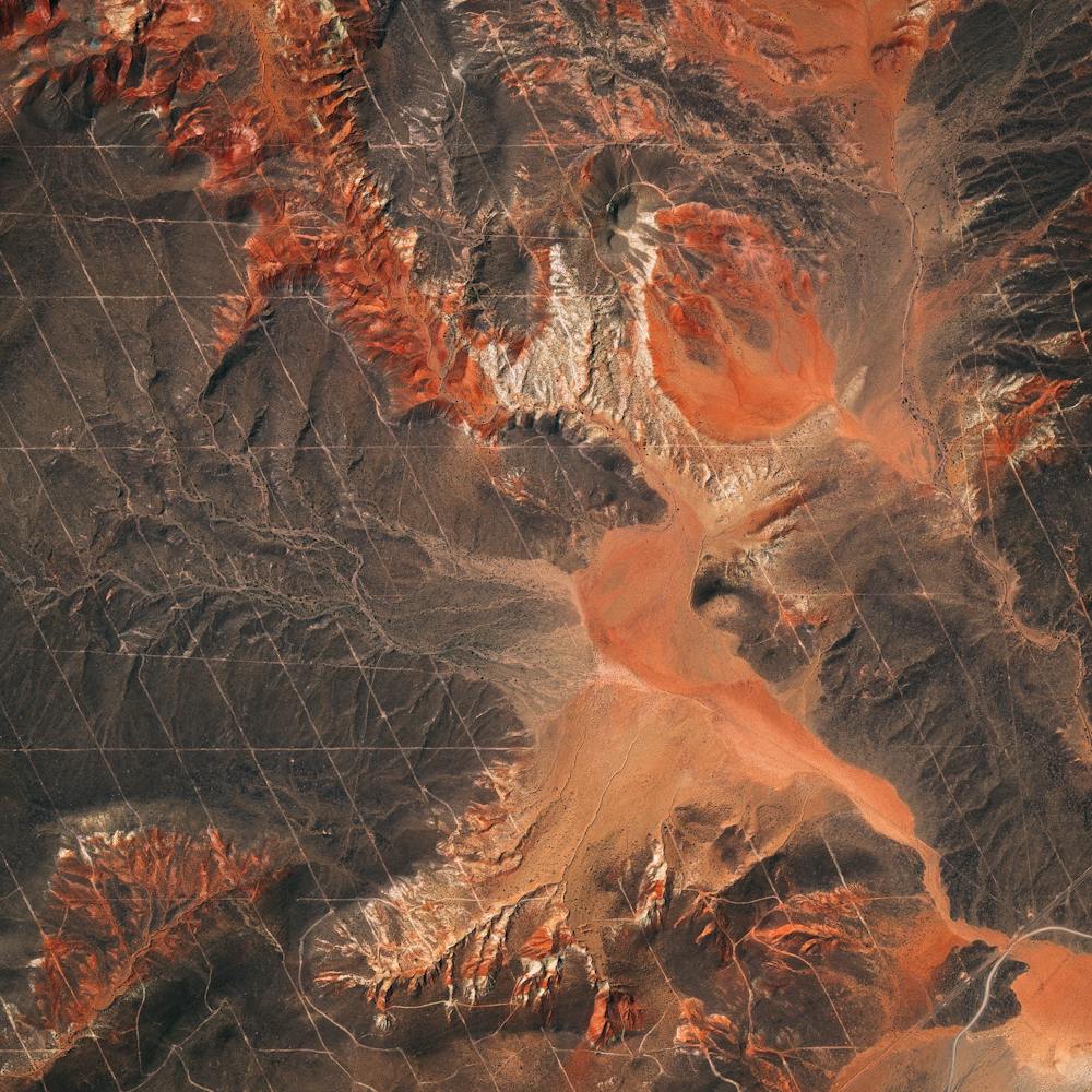
Mesa Mobile Homes
33.410401°, -111.724340° - 33.410401°, -111.724340°Mobile home and RV parks cover a considerable portion of eastern Mesa, Arizona. Pictured on the right side of this Overview is one such park — the Venture Out RV Resort, a master-planned retirement community with more than 1,740 homes. Located about 20 miles (32 km) outside of Phoenix, Mesa is the largest suburban city by population in the United States, with upwards of 500,000 residents.
Nearmap
Mexico Beach Damage From Hurricane Michael
29.941389°, -85.406389° - Mexico Beach, Florida, USAA week ago today, on October 10th, Hurricane Michael made landfall near Mexico Beach, Florida, with sustained winds of 155 miles per hour (250 kmh). The Category 4 storm made history as the third strongest by pressure and fourth strongest by wind speed to make landfall in the continental United States. As shown in this Overview, Michael caused extensive damage to the community, so much so that FEMA Administrator Brock Long called the area “ground zero.”
Nearmap
Mexico City
19.407452°, -99.027845° - Mexico City, MexicoWith a population of 21.2 million people, Greater Mexico City is second-largest metropolitan area in the Western Hemisphere. The Nezahualcoyotl District is seen here. By the 1990s Mexico City had become infamous as one of the world's most polluted cities, but has improved the air quality of the city drastically since to be roughly comparable to Los Angeles.
Maxar Technologies
Miami Beach
25.783742°, -80.128644° - Miami Beach, Florida, USAUmbrellas and beachgoers dot the sands of Miami Beach, Florida, USA. This area is one of the most popular tourist destinations in the country, attracting nearly 15 million visitors each year. The #summer season officially starts this weekend with Memorial Day here in the United States, but I wish everyone a few days of rest and adventure wherever you are around the world!
Maxar Technologies
Miami Beach Algae Bloom (Juxtapose)
25.786111°, -80.127306° - Miami Beach, Florida USACheck out this Juxtapose, which shows a section of Miami Beach, Florida, before and after a massive bloom of sargassum algae washed ashore this summer. Sargassum is a brown, free-floating seaweed common in temperate and tropical oceans. This summer, it has overwhelmed shorelines along the East Coast of the United States, Gulf of Mexico, and the Caribbean. Researchers believe the influx is caused by rising surface water temperatures and nutrients dumped into the ocean from farming and deforestation around the world.
Nearmap
Michigan Tailings
46.408653°, -87.530031° - Negaunee, Michigan, United StatesTailings - the waste and byproducts from mining operations - are pumped into the Gribbens Basin next to the Empire and Tilden iron ore mines in Negaunee, Michigan, USA. Here, the materials are mixed with water to create a sloppy form of mud known as “slurry” that is pumped through magnetic separation chambers to increase the mine’s total output. For a sense of scale, this Overview shows approximately one square mile of the basin.
Maxar Technologies
Milan-Malpensa Airport (MXP)
45.629583°, 8.725802° - Milan, ItalyThis Overview shows Milan-Malpensa Airport in Milan, Italy. The airport is the second-busiest in Italy by international passenger traffic, handling 24.7 million passengers in 2018. It is also the busiest Italian airport for freight and cargo, handling more than 500,000 tons of international freight annually.
Maxar Technologies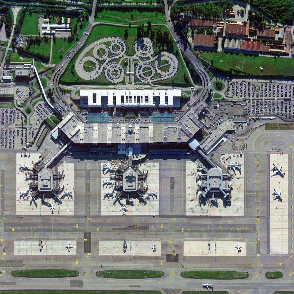
Mill Creek Wastewater Treatment Plant
39.111111°, -84.546778° - Cincinnati, Ohio, USAThe Mill Creek Wastewater Treatment Plant is the largest plant in the Metropolitan Sewer District of Greater Cincinnati, Ohio, treating roughly 100 million gallons (378 million liters) of wastewater a day. The sewer district’s service area encompasses more than 290 square miles (751 sq. km) and serves a population of more than 850,000.
Nearmap
Minsk, Belarus
53.900000°, 27.566667° - 53.900000°, 27.566667°Minsk is the capital and largest city of Belarus, situated on the Svislač River. Home to just under 2 million people, it is a modern city characterized by monumental Stalinist architecture — grand buildings, broad avenues and wide squares. In recent years, Minsk has been continuously decentralizing and more development is planned for several areas outside the city centre.
Maxar Technologies
Mir Mine
62.529461°, 113.993557° - Mirny, Eastern Siberia, RussiaThe Mir Mine is an inactive, open-pit diamond mine located in Mirny, Eastern Siberia, Russia. The mine is 1,722 feet (525 m) deep and has a diameter of 3,900 feet (1,200 m), making it one of the largest excavated holes in the world. Active for 44 years, the mine had an output of 10 million carats of diamond per year during peak production in the 1960s.
Maxar Technologies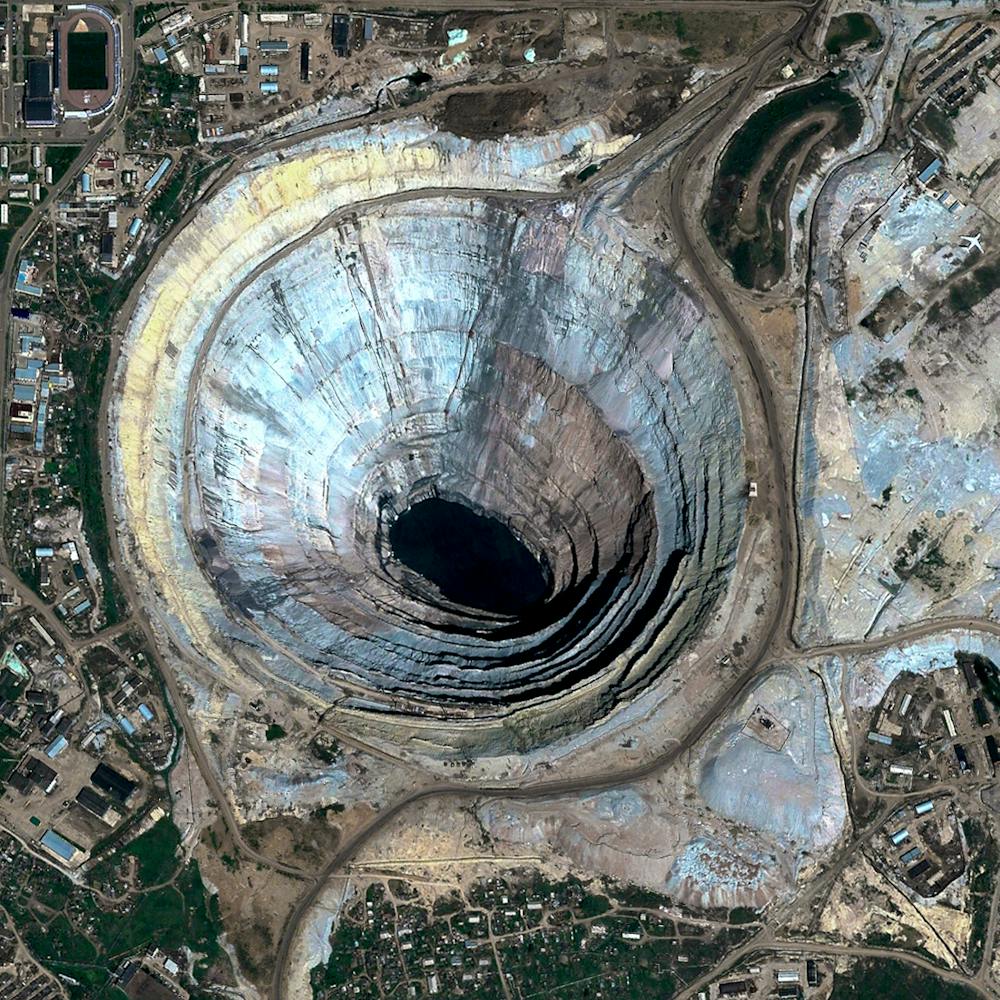
Mischief Reef
9.916667°, 115.533333° - Spratly Islands, South China SeaThe New York Times published a fascinating piece this morning on Chinese island building in the South China Sea. Dredgers - the boats you see here around "Mischief Reef" - pump sediment from the ocean up into floating pipes, and deposit the material onto the reef to increase land area. This enables the large-scale construction projects currently underway on the newly formed islands. See the full story .
Maxar Technologies
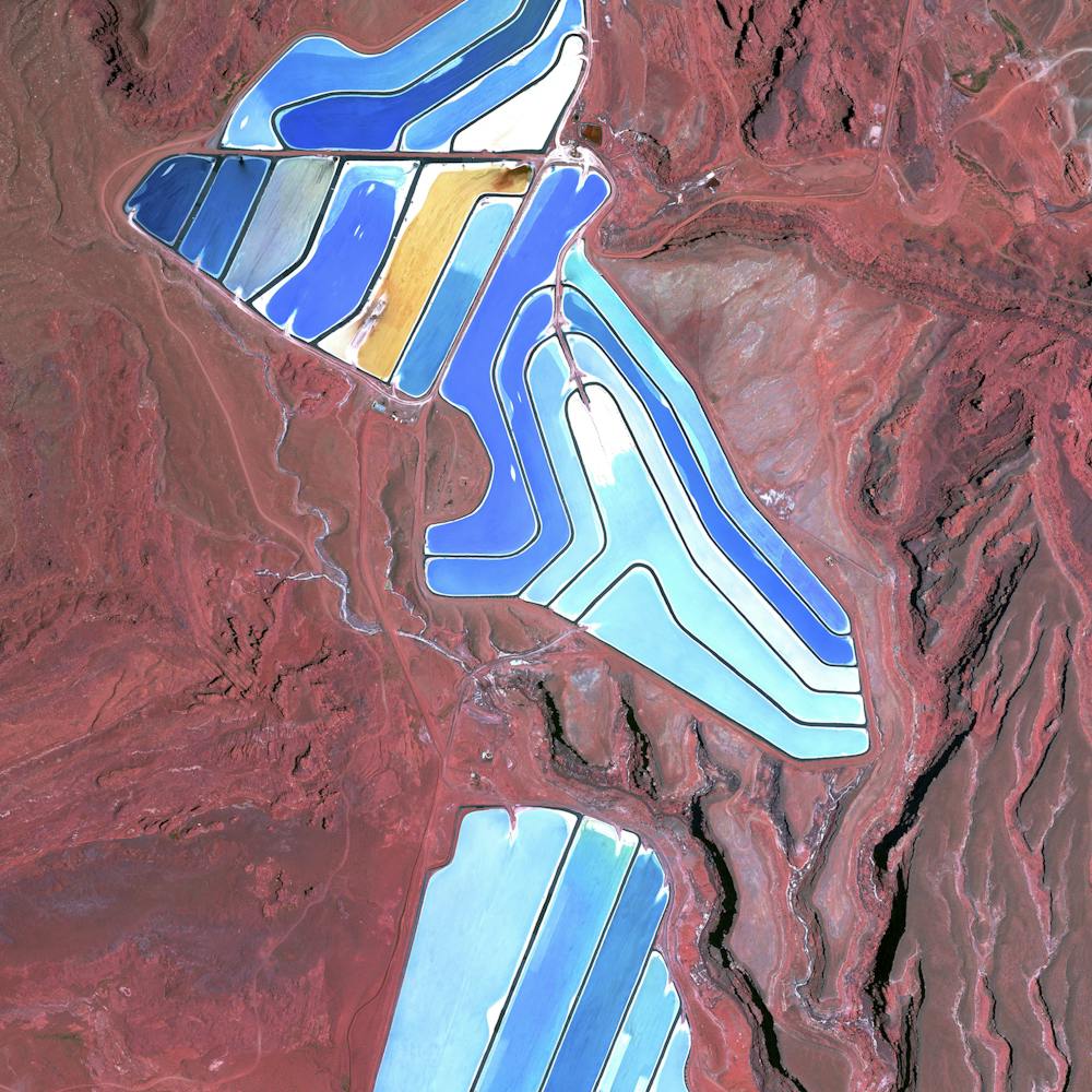
Moab Potash Evaportation Ponds
38.485583°, -109.684611° - Moab, Utah, USAEvaporation ponds are seen at the Intrepid Potash Mine in Moab, Utah, USA. The mine produces muriate of potash, a potassium-containing salt used widely by farmers in fertilizer. The salt is pumped to the surface from underground brines and dried in massive solar ponds that vibrantly extend across the landscape. As the water evaporates over the course of 300 days, the salts crystallize out. So why are you seeing such vibrant colors? The water is dyed with these vibrant colors to reduce the amount of time it takes for the potash to crystallize; darker water absorbs more sunlight so it gets hotter and the water evaporates quicker.
Maxar Technologies