Explore
 Shop
Shop About
About Search
Overview Index
Great Sandy Desert
-20.000000°, 125.000000° - -20.000000°, 125.000000°The Great Sandy Desert is the second-largest desert in Australia, covering 110,036 square miles (284,993 square km) in the northwestern part of the continent. Despite its name, the western portion of the desert is almost devoid of sand, but is characterized by complex geology — as shown in this Overview. The Great Sandy Desert is sparsely populated by indigenous Australian communities and mining centers.
United States Geological Survey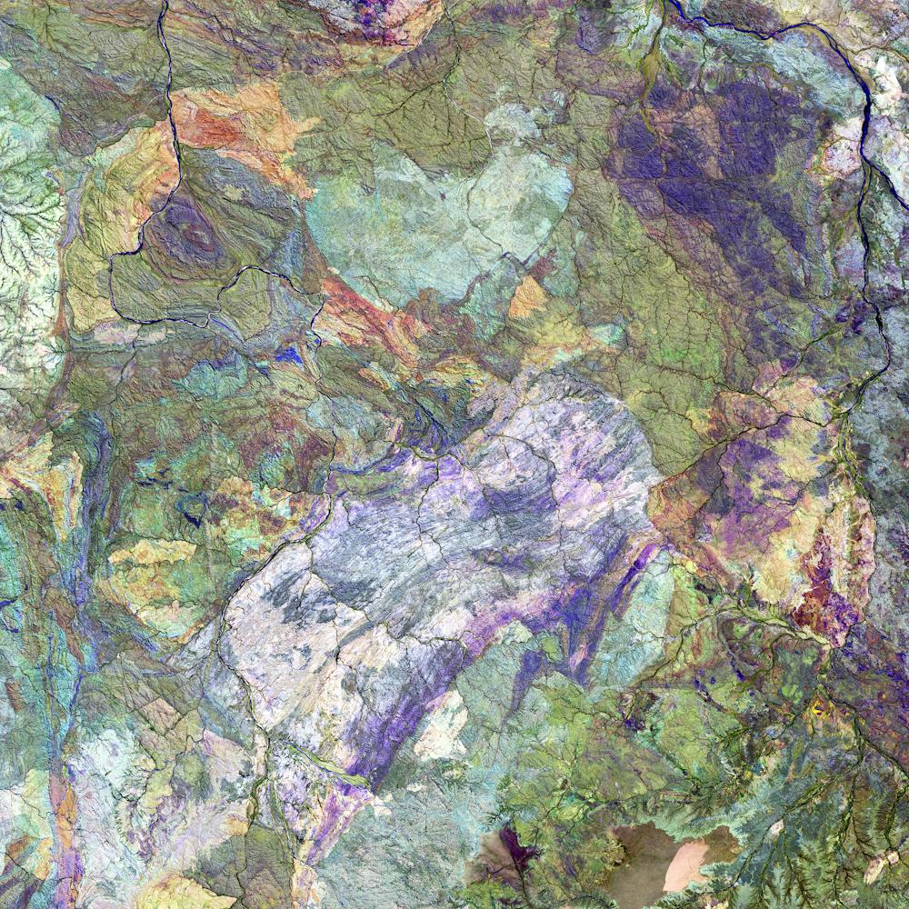
Greater Caucasus Mountains
43.598917°, 40.358111° - Russia / GeorgiaThe Greater Caucasus Mountains form a natural border between Russia and Georgia, stretching east to west from the Black Sea to the Caspian Sea. This Overview shows a stretch of mountains in Abkhazia, a de facto and partially recognized republic in northwestern Georgia. Disputes over the status of this region led to the War in Abkhazia from 1992 to 1993 and remains a central issue in Georgia-Russia relations today.
Maxar Technologies
Greek Olive Groves
35.078525°, 25.047392° - Ινία, GreeceOlive tree groves surround the village of Ινία, Greece. Approximately 90% of all harvested olives are turned into oil; the remaining 10% are eaten as table olives.
Maxar Technologies
Griend
53.251389°, 5.254167° - Griend, NetherlandsGriend is a small, uninhabited Dutch island located in the Wadden Sea, roughly 62 miles (100 km) northwest of Amsterdam. In the Middle Ages, the island housed a walled settlement and monastery, which were destroyed by St. Lucia’s flood in 1287. Later, a few farmers inhabited Griend between the 18th and 19th centuries, but continuous erosion pushed them away — the island remains only 25 acres (10 hectares) in size today.
Maxar Technologies
Guadalajara
20.676667°, -103.347500° - Guadalajara, MexicoGuadalajara is the capital of and largest city in the Mexican state of Jalisco, with upwards of 5 million people living in its metropolitan area. It is also the second most densely populated municipality in Mexico, behind Ciudad Nezahualcóyotl. Guadalajara is a Mexican cultural hub, considered by many to be the home of mariachi music.
Maxar Technologies
Guadalajara
20.689540°, -103.312179° - Guadalajara, MexicoGuadalajara is the second most populous city in Mexico with a population of nearly 1.5 million. It is also one of the country’s cultural centers, considered by many to be the home of mariachi music.
Maxar Technologies
Guadalajara
20.687580°, -103.307078° - Guadalajara, MexicoGuadalajara is the fourth most populous city in Mexico with a population of nearly 1.5 million. It is also one of the country’s cultural centers, considered by many to be the home of mariachi music.
Maxar Technologies
Hạ Long Bay
20.843408°, 107.009542° - Quảng Ninh Province, VietnamHạ Long Bay, located in the Quảng Ninh Province of Vietnam, is a stunningly beautiful destination. Here, towering limestone pillars and tiny islands topped by rich, green forests rise from the waters of the Gulf of Tonkin. Halong translates as 'where the dragon descends into the sea' and local legend suggests that this seascape was created when a great mountain dragon charged towards the coast, its flailing tail gouging out the valleys and crevasses in its path.
Maxar Technologies
Halong Bay
20.900000°, 107.200000° - Quảng Ninh Province of VietnamHạ Long Bay, located in the Quảng Ninh Province of Vietnam, is a stunningly beautiful destination. Here, towering limestone pillars and tiny islands topped by a rich, green forest rise from the beautiful waters of the Gulf of Tonkin. Halong translates as 'where the dragon descends into the sea' and local legend suggests that this seascape was created when a great mountain dragon charged towards the coast, its flailing tail gouging out the valleys and crevasses in its path.
Maxar Technologies
Hamburg
53.550530°, 9.969369° - Hamburg, GermanySituated on the River Elbe, Hamburg is the second largest city in Germany and eighth largest in the European Union. The city center, seen here, is situated around the Binnenalster, one of two artificial lakes built within its limits. Hamburg also contains the second largest port in Europe, which ships roughly 134 million tons of goods every year.
Maxar Technologies
Hardy Reef - Great Barrier Reef
-18.286111°, 147.700000° - Great Barrier ReefThis Overview captures a small segment of the Great Barrier Reef, located off the coast of Queensland, in northeastern Australia. Composed of more than 2,900 individual reefs and 900 islands, the reef system is Earth's largest structure made up of living things. The Great Barrier Reef stretches for more than 1,400 miles (2,300 km) and covers an area of roughly 130,000 square miles (344,400 sq. km).
Maxar Technologies
Harris Cattle Ranch
36.305402°, -120.258655° - San Joaquin Valley in CaliforniaHarris Cattle Ranch is located in the San Joaquin Valley in California. Spanning 800 acres with a a cattle population of over 100,000, the facility produces 150 million pounds of beef per year, making it the largest beef producer on the West Coast of the United States.
Maxar Technologies
Hartsfield-Jackson Atlanta International Airport (ATL)
33.640333°, -84.435139° - Atlanta, Georgia, USAHartsfield-Jackson Atlanta International Airport covers 4,700 acres (1,902 hectares) of land approximately 7 miles (11 km) south of central Atlanta, Georgia. It has 209 domestic and international gates and five parallel runways, which handle upwards of 900,000 flights per year. Hartsfield-Jackson has been the world’s busiest airport by passenger traffic since 1998 — it serviced 103 million travelers in 2017.
Nearmap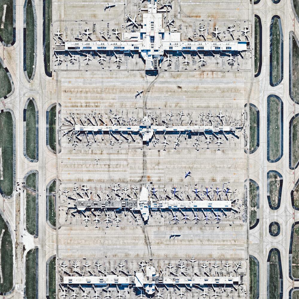
Hartsfield-Jackson International Airport
33.636667°, -84.428056° - Atlanta, Georgia, USAHartsfield–Jackson International Airport in Atlanta, Georgia, USA is the busiest airport in the world by total passengers and number of flights. In 2015, ATL accommodated more than 101 million passengers and 882,000 flights. Dozens of planes departing and arriving at concourses A-D are seen in this Overview.
Maxar Technologies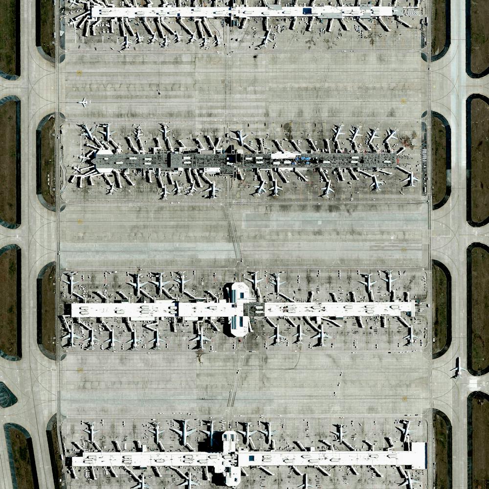
Heart Shaped Island
43.978331°, 15.382505° - Galešnjak, CroatiaHappy Valentine’s Day! We’re spreading the love today with this Overview of Galešnjak - a naturally occurring heart-shaped island, located off the coast of Croatia.
Maxar Technologies
Heart-shaped Lake
41.303953°, -81.901729° - Columbia Station, Ohio, USAIt’s Valentine’s Day! Check out this heart-shaped lake in Columbia Station, Ohio, USA. Send this to that special someone and have a wonderful day!
Maxar Technologies
Heerhugowaard
52.666667°, 4.833333° - Heerhugowaard, NetherlandsHeerhugowaard, Netherlands is home to roughly 55,000 people. Because of extensive peat extraction and storm floods, many lakes developed in the region, including the one on which the town located. The reclaimed land of Heerhugowaard is situated three meters below sea level.
Maxar Technologies
Henderson Island
-24.335167°, -128.310444° - South Pacific OceanHenderson Island is a 14.4-square-mile, uninhabited landmass in the South Pacific Ocean. Recent studies have shown that this area has a higher density of plastic wash up on its shores than any other place on the globe. It is estimated that the island’s shores now contain 37.7 million items of debris, weighing a total of 17.6 tons.
Maxar Technologies
Henningsvær Soccer Pitch
68.149194°, 14.202139° - Henningsvær, NorwayCheck out this unique soccer pitch in Henningsvær, a fishing village located on several small islands in Norway’s Lofoten archipelago. Situated inside the Arctic Circle, this 74-acre (0.3 sq. km) village has a population of less than 500 people. Henningsvær is a popular tourist destination, attracting hikers, climbers, divers and snorkelers.
Maxar Technologies
Het Loo Palace
52.234167°, 5.945833° - Apeldoom, NetherlandsHet Loo Palace is located in Apeldoorn, Netherlands. “The Great Garden,” situated behind the residence, follows the general Baroque landscape design formula: perfect symmetry, axial layout with radiating gravel walks, parterres with fountains, basins, and statues.
Maxar Technologies
Highway interchange
29.975280°, -90.319194° - New Orleans, Louisiana, USAA highway interchange connects Interstate 310 and U.S Route 61 outside of New Orleans, Louisiana, USA. Because the roadways in this area were built on top of environmentally sensitive wetlands, construction platforms were mounted on top of concrete piles to minimize disruption with the terrain below.
Maxar Technologies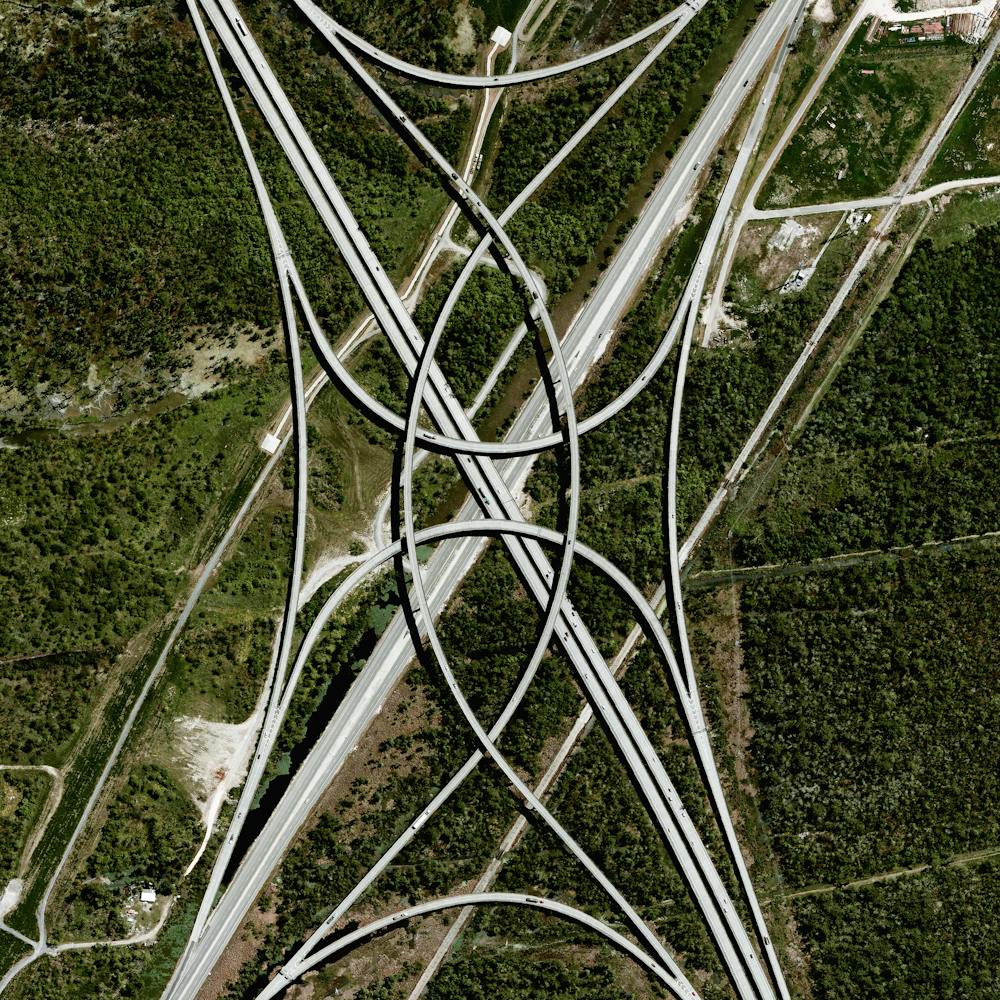
Ho Chi Minh City
10.776889°, 106.700806° - Ho Chi Minh City, VietnamHo Chi Minh City is the largest city in Vietnam with more than 10 million residents in its metropolitan area. Formerly known as Saigon, the city is expected to grow to 13.9 million by 2025. This stunning photo was sent to us by
Maxar Technologies
Hong Kong
22.118306°, 113.999195° - Hong KongHong Kong is an autonomous territory — and former British colony — in southeastern China. Originally a sparsely populated area of farming and fishing villages, it has become one of the world’s most significant financial centers and commercial ports. Hong Kong has the largest number of skyscrapers in the world, most of which surround Victoria Harbor and are captured in this Overview.
Maxar Technologies
Hong Kong International Airport (HKG)
22.308047°, 113.918480° - Hong KongHong Kong International Airport is located on Chek Lap Kok, an island in Hong Kong’s western waters. It is the world’s busiest cargo gateway and also one of the busiest passenger airports on Earth, handling upwards of 65 million passengers a year. Terminal 1, seen here, measures 570,000 square meters (6.1 million square feet), making it the third largest passenger terminal in the world.
Maxar Technologies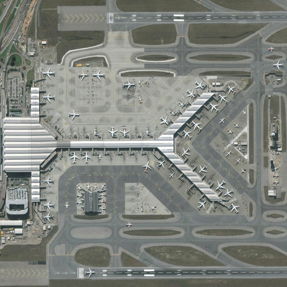
Honolulu
21.327976°, -157.939159° - Honolulu, Hawaii, USAHonolulu is the capital and largest city in the U.S. state of Hawaii. Located along the southeastern coast of Oahu Island, it is the most remote city of its size in the world. The Honolulu Volcanic Series is partially located inside the city, and Diamond Head — a prominent volcanic cone — is visible in this Overview along the southern coast.
Maxar Technologies
Hoover Dam
36.015844°, -114.738804° - Arizona / Nevada, USAHoover Dam is a 221-meter-high (726-foot), 379-meter (1,244-foot) concrete arch-gravity dam, located on the Colorado River at the border of Arizona and Nevada, USA. Constructed between 1931 and 1936 during the Great Depression, a workforce of approximately 20,000 poured a total of 3.33 million cubic meters (4.36 million cubic yards) of concrete to complete the structure – enough to pave a two-lane highway from San Francisco to New York City.
Nearmap
Houston Abandoned Cars
29.786157°, -94.878034° - Houston, Texas, USAHundreds of abandoned cars that were damaged by Hurricane Harvey are seen at the Royal Purple Raceway in Houston, Texas, USA. It is estimated that 30,000 now fill the lot and more than a half a million cars were damaged by the storm’s floodwaters. The cars will remain here until insurance adjusters assess the damage and process claims for each vehicle.
Nearmap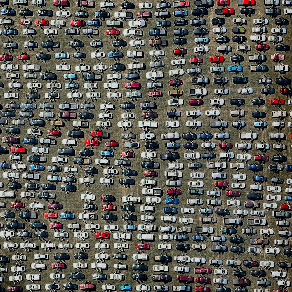
Hurricane Dorian
24.250000°, -76.000000° - BahamasThis image, captured by the European Space Agency's Copernicus Sentinel-3 satellite, shows Hurricane Dorian pummeling the Bahamas on Monday, September 2. Having reached Category 5 intensity with sustained winds of 185 mph (295 km/h), the storm is reported to be one of the most powerful Atlantic hurricanes on record. It is currently a Category 2 hurricane and is expected to continue up the southeastern coast of the United States. Several fatalities have been recorded and numerous homes and infrastructure have been destroyed.
ESA - European Space Agency
Hutt Lagoon
-28.172005°, 114.261002° - Western AustraliaHutt Lagoon is a massive lake in Western Australia that gets its pink color from a particular type of algae - Dunaliella salina - that grows in the water. The lagoon contains the world’s largest microalgae production plant, where the algae is farmed for its beta-carotene, which is then used as a food‑coloring agent and source of Vitamin A in other products.
Maxar Technologies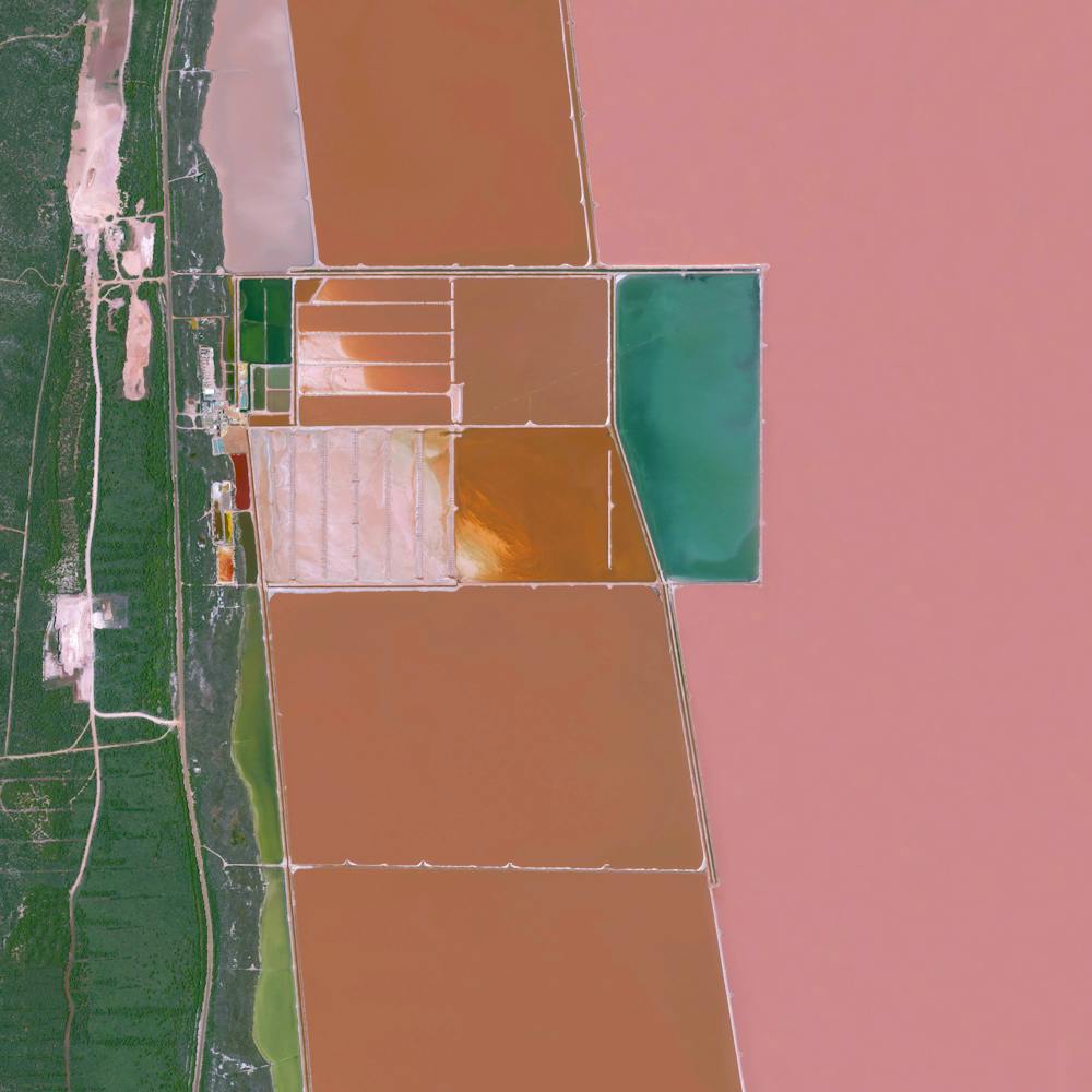
Hyundai Car Factory
32.281981°, -86.328442° - Montogomery, Alabama, USACars are parked next to the Hyundai production facility in Montgomery, Alabama, USA. The plant has a capacity of 300,000 automobiles and also contains the production facility for their engines. In 2015, 17.5 million cars and light trucks were sold in the United States, raising the total number of registered vehicles in the country to roughly 253 million.
Nearmap